Dorian: Columbia Cnty, the State, FHP, Lake City, etc. – Prepared for the Worst – A Sigh of Relief
Posted August 31, 2019 11:40 am

EOC Director Morgan (standing-left of screen)
directs the attendees to the State Emergency
Management broadcast which is about to begin.
COLUMBIA COUNTY, FL – Columbia County's Emergency Operations Center (EOC) was standing room only on Friday morning, August 30, as all of Columbia County's major agencies met to plan for the havoc Dorian could cause to the County and road transportation. Florida Gateway College, a possible staging and overflow area partner, was MIA.
Columbia County is a unique location in North Central Florida. I-75, the north-south mid state interstate, is an evacuation route for south, south central, and west Florida. The County's northern border is along the Georgia border. I-10 runs east-west across the County. I-10 is used to bring staging vehicles into Florida from the west.
When it comes to hurricanes, tropical storms, and evacuations, besides taking care of travelers, Columbia County also has its own citizens to worry about.
By the time the conference call with the State Emergency Operations Center came online at about 11:20 am Friday morning, there was standing room only in the County EOC.
The state immediately handed over the feed to the National Hurricane Center.
"National Hurricane Center (NHC), are you on the line?"
"National Hurricane Center (NHC), are you on the line?"
"Good morning everybody, this is Mike Brannan at NHC. Not a lot of change to the overall thinking at this point. Dorian is continuing to intensify."
Mr. Brannan continued with the forecast and announced that Dorian had become a category 4. "Extremely dangerous conditions - possibility of hurricane conditions extending well inward along portions of the peninsular," he advised.
He continued, "Isolated areas could see as much as 18 inches of rain, with wide spread totals of 6 to 12 inches expected."
Next, the NHC's storm surge expert came on the line. Storm surge is critical in calling for evacuations.
An EOC person called in and said folks are waiting on surge figures before calling for evacuations and was advised that information would "be out maybe tomorrow."
The NHC was predicting a storm surge of "10 feet plus" where the storm hit land.
Florida's Director of Emergency Management, Jared Moskowitz, came back on the line and told Florida, "One thing I want to address with the counties, we're not going to tell you guys when to pull the trigger on evacuations. Those decisions are made locally."
He added, "Labor Day Weekend is cancelled."
Everybody chuckled.
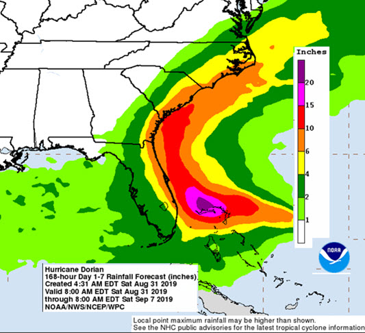
The latest NOAA rain event map (valid August 31,
8 am).
Director Moskowitz said that Florida Emergency Management secures charter busses for underserved populations that need to be evacuated. "Those needs have to be requested."
Director Moskowitz announced to North Florida counties that he was looking for staging areas. "I've got a lot of stuff coming into the state. I've got fuel. I've got –unintelligible. I need staging areas. I know Columbia is on the phone. I know you are right there on the edge of things right now Shane [Columbia County EOC Director, Shane Morgan]. If I could get to the airport. There are all kind of places up there that I need some help with if you can get me a spot."
Director Moskowitz advised counties, hospitals, etc. to order fuel now. "Don't wait. Do it now."
He continued, "You are going to begin seeing state escorts, FHP, on fuel. Be aware that it is going to start happening."
Director Moskowitz continued and when he completed his information County Emergency Management Director Morgan turned the meeting over to the County Commission and Chairman Ronald Williams.
Commissioner Williams commended the County's first responders.
Director Morgan read a County Emergency Declaration into the record. It was approved by the County Commission.
Columbia County Public Works and City Agencies are Ready
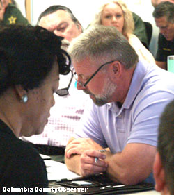
Kevin Kirby goes over Columbia County's on the
ground storm preparations. LCPD Chief Gilmore in
foreground. Clerk of the Courts P. DeWitt Cason
in background.
County Manager Ben Scott introduced Assistant County Manger and Public Works Director Kevin Kirby. Mr. Kirby explained that all personnel would be taking care of their personal business over the weekend. Leave had been cancelled beginning Tuesday morning. "All departments are to replenish supplies. Sand bags will be available Saturday, Sunday, Monday, and Tuesday from 8-5 at Columbia County Public Works and South Columbia Sports Complex in Fort White. The elderly and disabled will be assisted."
Mr. Kirby said no work is to be done on private property.
City Manager Joe Helfenberger said the City will be declaring a state of emergency at 4 pm. It did.
Mr. Helfenberger said if the winds go over 40 mph City Hall may be evacuated.
Sheriff Hunter said the Sheriff's Office is "ready now" and helping with staging.
LCPD Chief Gilmore said the Lake City Police Department "is ready to stand-up whenever the call is made."
Florida Highway Patrol: It does more that meets the eye.
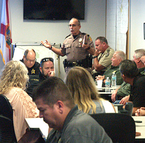
Veteran FHP Captain Mike Burroughs gets everyone
up to speed on FHP's progress and
responsibilities.
Captain Mike Burroughs of Florida Highway Patrol said, "We're in stand-by mode."
He explained that the Governor wants ESU (emergency shoulder use) implemented: both shoulders will be opened on I-75. "We are waiting for the Governor to pull the trigger on some other things."
Captain Burroughs said the bottleneck occurs at the state line. "Georgia wants nothing to do with ESU," he advised.
So far ESU has not been activated.
He continued, "We partner together with the Chief and the Sheriff. We get things done. Road Rangers will be out." Read more about Road Rangers here.
He said that FHP is prepared for flood situations.
Captain Burroughs concluded by explaining that FHP "has their eye on things and are waiting to hear from South Florida about their evacuations."
Florida Fish and Game said they are waiting to see what happens.
At the end of the meeting, the School District announced "the District is closed on Tuesday."
Epilogue: Latest Update (see rain event map above)
Early Saturday morning, the National Hurricane Center predicted Dorian would make a sharp northward turn with the eye of the storm not making landfall in Florida, but is headed for landfall near the South Carolina-Georgia borders.
Before this article posted, Columbia County's Emergency Management Director Shane Morgan told the Observer that things are looking up since the meeting yesterday morning, "While it can't be ruled out, with the turn of the storm, we are keeping our eye on the rain impact and are being mindful of the 'cone-of-error'."
Director Morgan sounded a lot more relaxed than he did yesterday morning, as it looks like Dorian will be a rain event in North and much of Florida.